


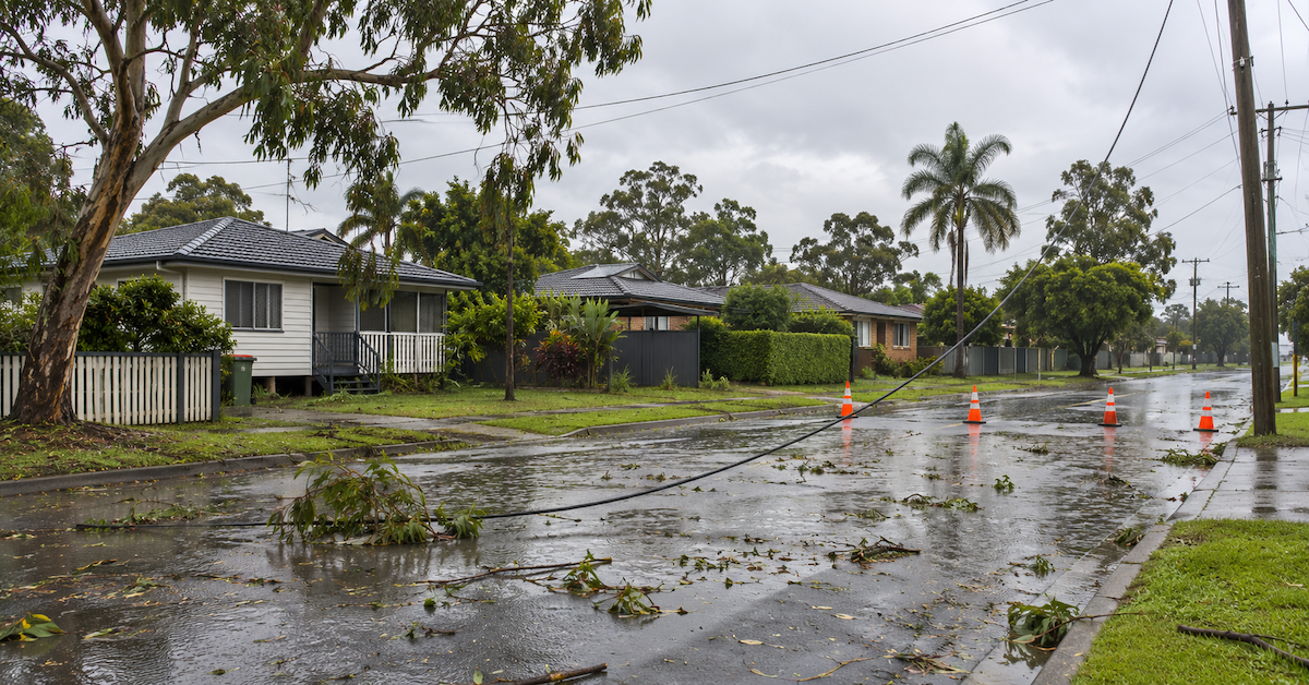
Heavy rain has flooded roads across parts of Brisbane as residents in Moreton Bay, Redlands and surrounding South East Queensland communities prepare for another round of potentially severe thunderstorms following Wednesday’s destructive weather.
The Bureau of Meteorology has warned that further storms could develop on Thursday, 12 November, bringing damaging winds, large hail and heavy rainfall capable of causing flash flooding.
The renewed threat comes as emergency crews continue clearing fallen trees, repairing damaged powerlines and responding to storm-related property damage. More than 80,000 homes and businesses across South East Queensland lost electricity at the height of Wednesday’s storms, with tens of thousands still without power on Thursday morning.

Brisbane, Redlands and Moreton Bay were all affected by intense storm activity, with rainfall observations showing how quickly conditions deteriorated across southern and eastern suburbs.
Intense rainfall floods Brisbane streets
Some of Wednesday’s heaviest rainfall was recorded in Brisbane’s southern and eastern suburbs, where intense downpours delivered substantial amounts of rain in just half an hour.
Bureau of Meteorology observations recorded 78 millimetres at Wishart in the 30 minutes to 4:39 p.m., while Chandler received 75 millimetres in the 30 minutes to 4:52 p.m. Nearby Burbank recorded 59 millimetres over a similar period.
The short, intense bursts of rainfall created flash-flooding hazards on local roads and placed additional pressure on drainage systems.

In Gumdale, Formosa Road was closed to through traffic between Stanbrough Road and Dairy Swamp Road because of flash flooding. Emergency crews were also called to Gumdale on Wednesday evening after a vehicle became stranded in floodwater. Swiftwater rescue personnel assisted the driver to safety.
Elsewhere in Brisbane, a falling tree struck two vehicles on Logan Road at Eight Mile Plains as severe winds swept through the area.
Brisbane Airport recorded a wind gust of 96 kilometres per hour at 5:03 p.m. on Wednesday, with the severe weather causing flight delays, cancellations and temporary operational disruption.
Motorists are being urged to check road conditions before travelling, particularly in areas affected by heavy rain and fallen trees. Road restrictions may be lifted or introduced as conditions change.
Redlands hit by heavy rain as storms move towards the bay
Redlands also experienced intense rainfall as Wednesday’s thunderstorms moved across eastern Brisbane and towards Moreton Bay.
The Bureau recorded 75 millimetres of rain at Leslie Harrison Dam in the 30 minutes to 4:47 p.m., placing the area among the locations that experienced the most intense short-duration rainfall during the event.
At 5:19 p.m., the Bureau issued a severe thunderstorm warning covering parts of Redland City, Brisbane and Moreton Bay. Storms detected around Ormiston and Brisbane Airport were capable of producing damaging winds and heavy rainfall that could lead to flash flooding.
Cleveland, Victoria Point, Ormiston and nearby islands were among the locations identified in warnings as the storms developed during the afternoon.
The State Emergency Service received 16 requests for assistance across Redlands following Wednesday’s weather, adding to hundreds of calls received throughout South East Queensland.
Residents in Cleveland, Capalaba, Wellington Point, Victoria Point and surrounding suburbs can check the Redlands Coast Disaster Dashboard for local warnings, road closures, electricity interruptions and emergency information.
The dashboard also provides evacuation information when relevant. No widespread evacuation order affecting Redlands has been established in the reports reviewed for this article.
Moreton Bay suburbs face further storm threat
Communities across Moreton Bay were also within the path of Wednesday’s severe weather, with storm cells developing near Caboolture and Burpengary before moving towards the coast.
The Bureau’s afternoon warnings identified conditions capable of producing damaging winds, large hail and intense rainfall across parts of the Moreton Bay region.
By early evening, the warning area extended towards the waters off Redcliffe, with Redcliffe and Scarborough among the locations forecast to be affected as the storms moved north and northeast.
Electricity interruptions were reported across the wider Moreton Bay region during Wednesday’s severe weather, although the largest concentration of damage to the Energex network occurred further south in Logan and the Scenic Rim.
For residents in Caboolture, Morayfield, Burpengary, North Lakes, Redcliffe and neighbouring suburbs, the City of Moreton Bay Disaster Dashboard provides a central source of local emergency updates.
The council’s dashboard includes weather warnings, road conditions, power outages and information about emergency facilities and available disaster support services.
Residents should continue checking official updates, particularly where local roads, waterways or properties remain vulnerable to another period of heavy rainfall.
Electricity restoration continues across the south-east
Restoring electricity remains one of the largest recovery operations following Wednesday’s storms, with widespread damage to powerlines, poles and other infrastructure.
Energex reported more than 400 sections of powerline brought down across South East Queensland, while more than 120,000 lightning strikes were recorded during the severe weather.
The worst electrical damage was concentrated in Logan and the Scenic Rim, where falling trees and damaged infrastructure left tens of thousands of properties disconnected.
By Thursday morning, approximately 55,000 properties across the region remained without power, according to ABC News reporting based on Energex information. Repair crews were being reinforced as assessments identified damaged poles and lines requiring replacement.
Some customers may face prolonged interruptions, particularly where access is obstructed or major infrastructure repairs are required.
Residents in Brisbane, Redlands and Moreton Bay can use the Energex Outage Finder to check reported power interruptions, affected locations and available restoration estimates.
Energex has warned residents to remain clear of fallen electrical wires and to treat damaged powerlines as live. Electrical emergencies can be reported on 13 19 62.
School closures and transport disruption
Wednesday’s storms also disrupted education across South East Queensland, with schools in the hardest-hit districts unable to operate normally because of damage and electricity interruptions.
Eleven state schools in the Logan City Council area were reported closed on Thursday morning, including campuses in Marsden, Crestmead, Jimboomba and Yarrabilba. Subsequent reporting placed the number of affected schools in the broader Logan and Jimboomba area at 13.
Within Brisbane, Mansfield State School cancelled a prep orientation session after experiencing telephone and internet disruption.
Parents across Brisbane, Moreton Bay and Redlands can check the Queensland Government’s current emergency school closures register for information about affected state, independent and Catholic schools.
The register should be checked before travelling, as schools may reopen once power, access and safety conditions have been assessed. Families should also consult their school’s own communications for local arrangements.
Transport disruption has extended beyond flooded roads. Brisbane Airport experienced delays and cancellations during Wednesday’s storms, while local road hazards included fallen branches, damaged traffic infrastructure and standing water.
Drivers can check QLDTraffic or the Transport and Main Roads Road Status Update for restrictions affecting state-controlled roads. Council emergency dashboards provide additional local information.
Emergency crews respond to hundreds of calls
The State Emergency Service received more than 320 requests for assistance across South East Queensland after Wednesday’s storms.
Logan accounted for the majority of the calls, but emergency crews were also deployed across Brisbane, Redlands and other affected areas.
The requests largely involved fallen trees, damaged roofs, blocked access to properties and other storm-related hazards. Brisbane recorded 41 requests, while Redlands recorded 16.
Emergency workers have been clearing debris, securing damaged structures and helping residents protect properties exposed to further rainfall.
Authorities are also urging residents to avoid floodwater and stay away from fallen electrical infrastructure. Even shallow floodwater can conceal damaged road surfaces, debris and strong currents.
More severe thunderstorms possible
The Bureau of Meteorology has forecast another period of unsettled weather across South East Queensland on Thursday, with severe thunderstorms possible from the Gold Coast through Brisbane and the Sunshine Coast towards Bundaberg.
Forecasters have identified damaging winds, large hail and heavy rainfall leading to flash flooding as the main hazards.
The threat is particularly concerning for communities still dealing with damaged buildings, blocked access and electricity interruptions from Wednesday’s storms.
Storm activity may ease in some districts on Friday before increasing again over the weekend as another weather system develops across inland Queensland.
Residents should monitor the Bureau of Meteorology’s Queensland warnings and check their local council’s emergency information before making travel plans.
What residents should do
- Check weather warnings before travelling
- Avoid flooded roads and never drive through floodwater
- Stay clear of fallen powerlines
- Charge phones and devices while power is available
- Secure loose outdoor items where safe
- Call SES on 132 500 for non-life-threatening storm damage
- Call 000 in a life-threatening emergency
Published 12-Nov-2026